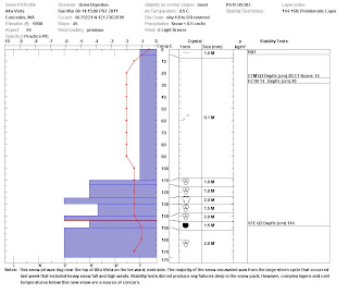
This week's snow pit is from the east side of Alta Vista and features the massive amount of new snow that we received during last week's storm cycle.
As you can see from the pit graph, there is small sun crust at the surface (that made for bad skiing) and below that is a 105 cm layer of cold, new snow. This layer has settled about 5" and continues to stabilize. Below this layer there are a number of complex ice crust layers that were observed just below the surface in the Feb. 9th snow pit near The Castle in the Tatoosh Range. These layers remain a source of instability and are acting as release surfaces for the deep slab avalanches that have been occurring in Washington.

Stability tests from the Alta Vista snow pit did not indicate deep instability. The compression, extended column, and the Rutschblock tests had failures either near the surface or did not fail. However, as noted by NWAC, even as the snowpack stabilizes there are still persistent weak layers, and localized areas throughout the region are experiencing large, slab releases.
The forecast is showing another series of fronts that are expected to cross the Northwest through the end of the weekend, bringing significant new snow accumulation. Cautious route finding is encouraged if traveling in the backcountry.
No comments:
Post a Comment